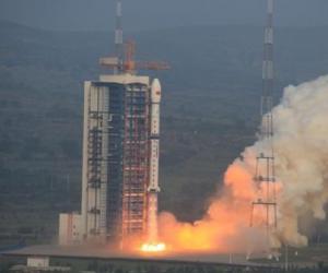
China launched a Long March 4C rocket on Tuesday. The rocket has deployed radar remote sensing satellite into the Earth’s orbit at an approximate distance of 460 miles from the planet. The aim of this satellite is to keep a track of the oceans, crops and resources, along with natural disasters. The three-stage launcher took off from the Taiyuan space center at 2255 GMT.
Subsequently, the rocket changed its direction to south to deploy the Gaofen 3 spacecraft into polar orbit. According to reports, the launch took place at 6:55 am on Wednesday. According to the data released by the US military’s Joint Space Operations Center, the satellite was deployed by the rocket into the orbit at an approximate altitude of 740 kilometers.
The Gaofen 3 spacecraft is now in the orbit of the Earth at an inclination of 98.4 degrees to the equator. The satellite is being operated by civilians and will be commencing its mission that will last for eight years. The mission of the satellite is to gather all-weather imagery of the Earth in high-resolution from its location in the orbit.
The weight of the satellite is almost 3 metric tons, or 6,500 pounds, and is equipped with C-band synthetic aperture radar. Officials stated that Gaofen 3 is being anticipated to be instrumental in helping the authorities of China to ensure improved reaction to natural disasters such as earthquakes and floods.
Gaofen 3 will be part of a range of optical and infrared imaging satellites that have been launched by the government of China under its Gaofen program. The target of the new spacecraft, irrespective of the weather conditions, is to capture the images of the Earth day and night. Gaofen 3 has been built by China Academy of Space Technology and is the sixth satellite that has been launched as part of the Gaofen project.
A report published in Spaceflight Insider informed, "The launch marks the 11th out of more than 20 orbital missions planned to be conducted by China before year-end. Tuesday’s liftoff comes just four days after the country sent its Tiantong-1 No. 1 communications satellite into space. As was the case with the Aug. 5 launch, Gaofen-3 was also blasted off unannounced."
According to Chinese media reports, Gaofen-3 will be used for disaster warning, weather forecasting, water resource assessments, and the protection of maritime rights. The satellite will be mainly used by the country’s State Oceanic Administration.
Xinhua press agency reported Gaofen-3 is able to provide high-definition remote sensing data over long periods of time as it can capture continuous imaging for nearly one hour during ocean observation. The agency underlined the new spacecraft is also capable of providing clear images of all roads, buildings, and boats. The satellite is expected to deliver all its services for up to eight years.
According to a report in Spaceflight Now by Stephen Clark, "Tracking data published by the U.S. military’s Joint Space Operations Center indicated the Long March 4C rocket placed the Gaofen 3 satellite into orbit at an altitude of nearly 460 miles (740 kilometers). The craft is circling Earth at an inclination of 98.4 degrees to the equator."
“The satellite will provide high-quality, reliable and quantitative images for ocean monitoring, water conservancy monitoring and disaster monitoring, which will give strong technological support to building our maritime strength and the One Belt One Road project,” said Wu Yanhua, deputy head of China’s State Administration of Science, Technology and Industry for National Defense (SASTIND), in an interview with Chinese state television.
Gaofen 3 is part of the China High-resolution Earth Observation System, or CHEOS, a network of satellites supplying near-realtime data to Chinese government agencies such as the State Oceanic Administration, the Ministry of Civil Affairs, the Ministry of Water Resources, the China Meteorological Administration, and other sectors, according to a statement issued by SASTIND.
A latest study suggested that Saturn's large moon Titan is home to surprisingly deep canyons packed with liquid hydrocarbons.
Researchers said that the recently found Titan canyons are nearly 1,870 feet deep and have slopes at least 40...

A new study by the Massachusetts Institute of Technology (MIT) has revealed that Istanbul lies...

According to a Monday report published by independent cybersecurity journalist Brian Krebs on...

In an announcement made via a Twitter post published last Thursday, Tesla Motors’ CEO Elon Musk said that the electric vehicle manufacturer has efforts underway to make changes to the radar system in its vehicles.
The changes being planned...

The drought conditions in California is widening economic split in California. The prospect of...

In a recently published blog post, tech giant Google has revealed that the superior intelligence...

In recent years, gender gap in pay has been a hot topic of discussion. On Wednesday, Amazon. com Inc said its female employees are paid equally as their male counterparts. The results which came from a recent survey were disclosed under pressure...

According to a latest research one volcanic eruption can...

A latest study has discovered that a solar storm that...
© 2011 AustrianTribune - Tribune Online Services. All times CET (GMT + 1.00).